About the Authors
Mark and Diana Doyle are authors of the popular cruising guide and electronic charting series, On the Water ChartGuides (formerly Managing the Waterway). They also write articles for professional, boating, and nature publications.
Mark retired from high-tech, specializing in color digital imaging with companies such as Kodak, Agfa, and Xerox. He is the founder of Bluewater Yacht Deliveries and holds a 100-ton USCG Master’s License. His first roundtrip of the Atlantic Intracoastal Waterway was in 1987.
Diana is a former university professor with a Ph.D. from Yale and holds a 50-ton USCG Master’s License. She is the founder of the SeaBC Sea Bird Count and is currently Tools of the Trade department editor for American Birding Association's Birding magazine. A lifetime birder, she enjoys sharing her experiences though her writing.
They have sailed extensively between Canada and the Bahamas, including the Gulf of Mexico, Inland Rivers, and all five Great Lakes. Over the years their boat inventory has included a C-Dory Pilothouse 22, Catalina 30, C&C; 30, Allied Princess 36, Vagabond 47, and PDQ 36 catamaran. They are currently on the East Coast surveying aboard their PDQ 34 power catamaran, m/v Semi-Local.
How We Do It
We're cruising cruising guide authors, out "on the water" full time using high-tech tools to better illustrate our survey work. Techniques such as geo-tagging digital photos and marrying depth soundings with anchorage approach tracks allow us to produce more visually rich and informative CruiseGuides, ChartGuides, and AnchorGuides.
Many boaters ask us how we do it—just the two of us, with no office, and no staff. We're fortunate in that we have very different but complementary skills, interests, and backgrounds! We do all of our own digital surveying, geo-photography, and desktop publishing using Mark's background in high-tech. Diana, as a former professor, is comfortable handling research, writing, editing, and data management.
Once we assemble the text, photo, and chart assets, we park it and plug in Semi-Local's umbilical for unlimited electricity, fresh water, and blessed air conditioning. Then, like a Transformer toy, our big-screen Mac rotates from its seaworthy strapped-down position to become an onboard production workstation. There is also a duplexing laser printer, wide format ink jet proofer, document scanner, disk array tower, and two networks at the ready. We design and produce the printer-ready files using InDesign, Photoshop, Illustrator, and other desktop publishing tools. Books are printed in and shipped from Minnesota (our boat's hailing port). Our website and online secure shopping cart is handled by our best friend and webmaster (also an ICW veteran).
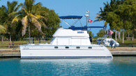
So, when you spot our PDQ power catamaran, with its blue-and-white logo, you're seeing the "corporate headquarters" of On the Water ChartGuides—where it's 9-to-5 somewhere.
About On the Water ChartGuides
In 2005, while brainstorming the content and layout of our first guide, we realized the solution to a successful migration was simple—either you manage the Waterway or the Waterway manages you. Having the resources to plan ahead makes the difference between stressful and uncertain day-to-day challenges or your vessel becoming a magic carpet ride to enjoy the local sights, sounds, and experiences.
We publish cruising guides, reference books, and electronic chart catalogs that help boaters follow their dreams to new destinations. To help you accomplish the goal of a safe, yet relaxed and enjoyable cruise, we provide the information you need, where and when you need it. It’s not enough to have boatloads of information—by their nature, all cruising guides include too much data. What matters most is how the information is organized and presented. And that the information is presented concisely and consistently. Our mission is to do the organizational work for you, preparing and presenting resources in a way that let you stay in control and manage your dream.